
open
🕗 opening times
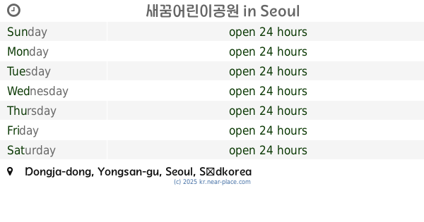
| Sunday | open 24 hours | |||||
| Monday | open 24 hours | |||||
| Tuesday | open 24 hours | |||||
| Wednesday | open 24 hours | |||||
| Thursday | open 24 hours | |||||
| Friday | open 24 hours | |||||
| Saturday | open 24 hours | |||||
Itaewon-dong, Yongsan-gu, Seoul, South Korea
contacts phone: +82
larger map & directionsLatitude: 37.5382051, Longitude: 126.9892748


Nancy E
::Cute neighborhood park. It has slides, swings, exercise machines, and benches.
Tuncay TUNCA
::A very comfortable place for kids and also teenagers and adults to get relax. At every time period of the day, it can be used for several outdoor purposes such as doing yoga, physical training, play garden and getting relaxed. But, there is one important issue I have to say that, in the night time, the lightning is not enough and you can see some bad behavioured guys while having alcohol over there.
Ali Cho
::Nice small park with good atmosphere especially at night time
Joe Halstead
::Good place to walk your small dog. Apart from that it's for kids, old people, and at night young couples.
Oliver Rosée
::This used to be a nice kid's playground, but it has been renovated for much older children and lacks safety and support for pre-school kids now. Slides are not accessible, swings have no protective fences, jungle gym is gone and there are a few dangerous falling hazards. Trees have been felled and seating used to be more plentiful. Positive: toilets are now available.