Establishment nearby 제일의원
South Korea
Establishment nearby 제일의원
제일의원
115-17 Janghowon-ri, Janghowon-eup, Icheon, Gyeonggi-do, South Korea
contacts phone
:
+82 31-641-5533
Latitude:
37.1177124
, Longitude:
127.6310855
larger map & directions
read more
nearest Establishment
27 m
농협은행 장호원지점
KR, 39-4 Janghowon-eup, Janghowon-ri, Icheon
Bank
Point of interest
Finance
Establishment
read more
46 m
청미새마을금고
39-3 Janghowon-ri, Janghowon-eup, Icheon
Bank
Finance
Point of interest
Establishment
read more
227 m
장호원신용협동조합
58 Janggam-ro, Janghowon-eup, Icheon
Bank
Finance
Point of interest
Establishment
read more
232 m
장호원우체국
South Korea
Post office
Finance
Point of interest
Establishment
read more
279 m
의료법인목민의료재단장호원요양병원
162-16 Janghowon-ri, Janghowon-eup, Icheon
Hospital
Point of interest
Health
Establishment
read more
481 m
음성감곡우체국
2 Janggam-ro 126beon-gil, Gamgok-myeon, Eumseong
Post office
Finance
Point of interest
Establishment
read more
810 m
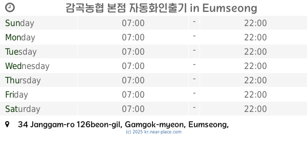
감곡농협 본점 자동화인출기
34 Janggam-ro 126beon-gil, Gamgok-myeon, Eumseong
Atm
Finance
Point of interest
Establishment
read more
1.056 km
효성ATM감곡오향점B
518-3번지 Ohyang-ri, Gamgok-myeon, Eumseong
Atm
Point of interest
Finance
Establishment
read more
1.067 km
감곡농협 오향지점 자동화인출기
198 Janggam-ro, Gamgok-myeon, Eumseong
Atm
Point of interest
Finance
Establishment
read more
1.182 km
GS25 감곡오향점
753 Ohyang-ri, Gamgok-myeon, Eumseong
Supermarket
Grocery or supermarket
Store
Food
Point of interest
Establishment
read more
3.086 km
GS25 극동정보대점
155-1 Danpyeong-ri, Gamgok-myeon, Eumseong
Supermarket
Grocery or supermarket
Food
Point of interest
Store
Establishment
read more
12.097 km
페이카나
8-6 Taepyeongjungang 1-gil, Ganam-myeon
Restaurant
Food
Point of interest
Establishment
read more
14.637 km
신한은행ATM
무극리 585-16 Geumwang-eup, Eumseong
Atm
Finance
Point of interest
Establishment
read more
14.764 km
Anseong M Hotel
KR, 156-6 Iljuk-myeon, Geumil-ro, Anseong-si
Lodging
Point of interest
Establishment
read more
16.671 km
작은뜰카페
South Korea
Cafe
Food
Point of interest
Establishment
read more
📑
all categories
Accounting
Administrative area level 1
Airport
Amusement park
Aquarium
Art gallery
Atm
Bakery
Bank
Bar
Beauty salon
Bicycle store
Book store
Bowling alley
Bus station
Cafe
Campground
Car dealer
Car rental
Car repair
Car wash
Casino
Cemetery
Church
City hall
Clothing store
Colloquial area
Convenience store
Courthouse
Dentist
Department store
Doctor
Electrician
Electronics store
Embassy
Establishment
Finance
Fire station
Florist
Food
Funeral home
Furniture store
Gas station
General contractor
Grocery or supermarket
Gym
Hair care
Hardware store
Health
Hindu Temple
Home goods store
Hospital
Insurance agency
Jewelry store
Laundry
Lawyer
Library
Liquor store
Local government office
Locality
Locksmith
Lodging
Meal delivery
Meal takeaway
Mosque
Movie rental
Movie theater
Moving company
Museum
Natural feature
Night club
Painter
Park
Parking
Pet store
Pharmacy
Physiotherapist
Place of worship
Plumber
Point of interest
Police
Post office
Premise
Real estate agency
Restaurant
Roofing contractor
Rv park, camping
School
Shoe store
Shopping mall
Spa
Stadium
Storage
Store
Subpremise
Subway station
Supermarket
Synagogue
Train station
Transit station
Travel agency
University
Veterinary care
Zoo
sublocality level 1
sublocality level 2
sublocality level 4
↑