Hospital nearby 모현센터의원
South Korea
Hospital nearby 모현센터의원
모현센터의원
210 Wangbang-ro, Sineup-dong, Pocheon-si, Gyeonggi-do, South Korea
contacts phone
:
+82 31-536-8998
website:
www.mhh.or.kr
Latitude:
37.8989595
, Longitude:
127.1995113
larger map & directions
read more
nearest Hospital
463 m
강병원
195-2 Sineup-dong, Pocheon-si
Hospital
Health
Point of interest
Establishment
read more
483 m
Gyeonggi Provincial Medical Center Pocheon Hospital
1648 Pocheon-ro, Pocheon-si
Hospital
Health
Point of interest
Establishment
read more
483 m
경기도의료원 포천병원
1648 Pocheon-ro, Pocheon-si
Hospital
Health
Point of interest
Establishment
read more
9.155 km
우리병원
661 Hoguk-ro, Soheul-eup, Pocheon-si
Hospital
Health
Point of interest
Establishment
read more
9.155 km
Pocheon Woori Hospital
661 Hoguk-ro, Soheul-eup, Pocheon-si
Hospital
Health
Point of interest
Establishment
read more
9.679 km
한양대병원서울벼뭔
115-5 Masong-ri, Tongjin-eup, 포시
Hospital
Health
Point of interest
Establishment
read more
9.978 km
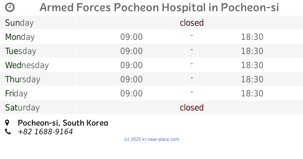
Armed Forces Pocheon Hospital
South Korea
Hospital
Health
Point of interest
Establishment
read more
12.801 km
내촌구두병원
479-7번지 Nae-ri, Naechon-myeon, Pocheon-si
Hospital
Health
Point of interest
Establishment
read more
12.817 km
동두천중앙성모병원
South Korea
Hospital
Health
Point of interest
Establishment
read more
13.053 km
로하스요양병원
422 Gangbyeon-ro, Dongducheon
Hospital
Point of interest
Health
Establishment
read more
14.134 km
양주소망병원
1741 Pyeonghwa-ro, Yangju-si
Doctor
Hospital
Health
Point of interest
Establishment
read more
14.7 km
인화병원
745 인화 병원, Soheul-eup, Gwangneungsumogwon-ro, Pocheon-si
Hospital
Point of interest
Health
Establishment
read more
16.349 km
에덴요양병원
160 Biryong-ro 1782beon-gil, Sudong-myeon, Namyangju-si
Hospital
Point of interest
Health
Establishment
read more
16.351 km
전암힐링센터
Biryong-ro 1782beon-gil, Sudong-myeon, Namyangju-si
Hospital
Health
Point of interest
Establishment
read more
18.413 km
Yeoncheon Public Medical Center
95 Eundaeseong-ro, Jeongok-eup, Yeoncheon
Hospital
Health
Point of interest
Establishment
read more
📑
all categories
Accounting
Administrative area level 1
Airport
Amusement park
Aquarium
Art gallery
Atm
Bakery
Bank
Bar
Beauty salon
Bicycle store
Book store
Bowling alley
Bus station
Cafe
Campground
Car dealer
Car rental
Car repair
Car wash
Casino
Cemetery
Church
City hall
Clothing store
Colloquial area
Convenience store
Courthouse
Dentist
Department store
Doctor
Electrician
Electronics store
Embassy
Establishment
Finance
Fire station
Florist
Food
Funeral home
Furniture store
Gas station
General contractor
Grocery or supermarket
Gym
Hair care
Hardware store
Health
Hindu Temple
Home goods store
Hospital
Insurance agency
Jewelry store
Laundry
Lawyer
Library
Liquor store
Local government office
Locality
Locksmith
Lodging
Meal delivery
Meal takeaway
Mosque
Movie rental
Movie theater
Moving company
Museum
Natural feature
Night club
Painter
Park
Parking
Pet store
Pharmacy
Physiotherapist
Place of worship
Plumber
Point of interest
Police
Post office
Premise
Real estate agency
Restaurant
Roofing contractor
Rv park, camping
School
Shoe store
Shopping mall
Spa
Stadium
Storage
Store
Subpremise
Subway station
Supermarket
Synagogue
Train station
Transit station
Travel agency
University
Veterinary care
Zoo
sublocality level 1
sublocality level 2
sublocality level 4
↑